


Agua
Salud
Landscape-scale research in the
Panama Canal Watershed Project
Projects and Stories
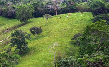


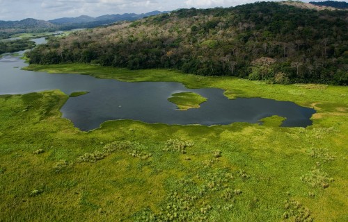
The Panama Canal Watershed is perhaps one of the tropics' clearest examples of ecosystem services in action. The basin’s fresh water transports four percent of seafaring world trade, generates $2.5 billion in annual revenue and sustains one of the fastest growing economies in the world today. Named for the Agua Salud River, the 700-hectare Panama Canal Watershed Project seeks to explain how different landscapes common in the rural tropics — from intact forests to cattle ranches — impact ecosystem services in an era of exploding population growth, ecosystem degradation, and global climate change.
Research
Agua Salud’s experimental plots include native tree plantations, silvopastoral and shade coffee systems, invasive grasslands, subsistence farms and forest regrowth ranging from a few years to many decades in age. Figuring out the hydrology of the basin — essentially accounting for every last drop of water that passes through it — is a primary goal of the project. Reforestation with native species, carbon sequestration, biodiversity restoration and disease ecology are also part of one of STRI’s fastest-growing research platforms. The research aims to inform policymaking decisions that have implications for billions of people throughout the tropics. The project’s large-scale reforestation and mixed-use experiments attract researchers interested in facets of landscape regeneration ranging from economics to the restoration of biodiversity.


Science in Action

Can we reduce carbon dioxide emissions by simply allowing forests to recover?

Economic Complexities of Forest Restoration: What’s in it for landowners?

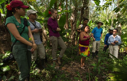
Seeking Win-Win solutions to combat climate change and improve livelihoods in Panama’s indigenous Ngäbe-Buglé Comarca

Predicting uncertain futures
for tropical landscapes

Secondary forests restore fresh water sources in degraded landscapes

A conversation about changing the future through better land management in the tropics

New bilingual videos feature tropical landscape management for a sustainable future

Native trees thrive in teak plantations and may protect the Panama Canal

Unraveling sustainable forest
management while in confinement

Words, Birds, and Watercolor:
an Interview with Charlotte Steeves

Agua Salud helps inform smart
land management decisions
through science
Weighing costs and benefits of motivating landowners to reforest the Panama Canal Watershed

Each tropical tree species
gets the nutrients it needs
In STRI’s carbon offset
program, everyone wins

Ira Rubinoff,
Emeritus Director,
retires from STRI


Lianas can suppress tree growth in young tropical forests for decades
")
Smithsonian releases guide to restoring tropical forests
")
Scientists question hydrological model for Panama Canal Watershed
")
Tropical rainforests in danger of losing tree diversity


People
Agua Salud staff helps to orient new visiting scientists.


Services and Resources
A steady influx of new scientific visitors and research projects make Agua Salud one of STRI’s fastest-growing research sites. Resources are still limited but there is housing near the research site some transportation available. Visiting researchers are usually based out of STRI’s Tupper Center headquarters, where Agua Salud’s administrative staff and laboratories are based. Making the 50km commute between Tupper and Agua Salud is one option for visiting researchers.

Experimental Catchments
Agua Salud’s experimental catchments are the foundation of the project’s research program. These include catchments of near-mature forest, managed forest, and secondary succession forests of various ages. There are also native timber plantations that are mixed-species or monoculture, and a teak plantation. Farmed landscape includes silvopastoral and shade coffee systems, and mixed-use subsistence lands including business-as-usual cattle ranching. Invasive canal grass also covers a catchment area.

Hydrological Data
Agua Salud’s sophisticated system of hydrological data collection builds on more than a century of monitoring in the Panama Canal Watershed. Along with a standardized system of gauged weirs to measure stream flow, the hydrology research measures water flow through soil at different depths, runoff, and water use by trees — sap flow and transpiration. The objective is to create physics-based models that can be applied to current and future conditions across a variety of landscape uses.

Physical Monitoring Program
Currently managed by the Physical Monitoring Program, the Agua Salud’s primary meteorological station is located at a location known as Celestino. Since 2015, the Celestino station has been monitoring rainfall, solar radiation (PAR, Global and net), Temperature, Relative Humidity, Wind speed and direction, as well as a calculated value for Evapotranspiration, from a 12m tall tower located at the top of a highest hills in the area.
Maps and Directions
The project lies roughly 50 km northwest of Panama City in Colón Province and can be reached by either via Transisthmian Highway or the toll road to Colón. To access the site, turn west at the town of El Giral, just north of the Chagres River.
Reaching the field sites usually requires a 4x4 vehicle. Road conditions during the dry season are typically okay but rainy season access can be limited. Transportation should be arranged by visitors and visits coordinated with the project manager.

Catchments
Contact us
Visiting Scientists
For principal investigators interested in conducting research at Agua Salud:
Emergencies
Report all emergencies to STRI security