
Leafcutter ants have blind
spots, just like truck drivers
")
More trees,
more water
Scientists question hydrological model for Panama Canal Watershed
January 17, 2014
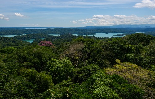
Agua Salud, Panama
A new model suggests reforestation could be detrimental to water resources in the Panama Canal. Smithsonian scientists warn of flawed methodology and emphasize case for long-term monitoring.
Each ship passing through the Panama Canal uses 52 million gallons of fresh water from Gatun Lake, which also provides drinking water for central Panama’s 2 million residents. Because a price can be put on water in Panama, the canal watershed provides an ideal situation for academics to model the economic and environmental effects of land-use decisions on ecosystem services like water availability, carbon storage and timber production. But one such study, published by Silvio Simonit and Charles Perrings from Arizona State University in the May issue of Proceedings of the National Academy of Sciences, prompted colleagues to challenge the results.
The Simonit and Perrings article projects the impacts of changes in forest cover on dry-season water flow, timber production and carbon sequestration. They predict that by reforesting grasslands, the amount of water flowing out into the Canal would be reduced. Simonit and Perrings go on to compare this to other land uses, predicting that it would be more profitable to reforest grasslands if carbon is priced at more than a certain amount.
")
")
")
")
")
")
But according to hydrologists Fred Ogden from the University of Wyoming and Bob Stallard of the U.S. Geological Survey and STRI, who have both worked in the Panama Canal watershed for several decades, the authors relied on a faulty model to estimate land-use effects on water flow, rendering their results essentially meaningless. “Simonit and Perrings applied the empirical CN model in a humid tropical forest where it is known not to work, at an inappropriate spatial scale (pixels) and used an invalid monthly time step requiring an invalid value of the parameter λ,” states their rebuttal, also published in PNAS.
The Smithsonian and the Panama Canal Authority, coordinating with Panama’s Environmental Authority (ANAM), set up a 30-year reforestation experiment spanning mature tropical forest, cattle pasture and reforestation plots and monitor the outflow of all of the major streams in this area. Ogden and Stallard, who together with several other hydrologists contributed to the design of the Panama Canal Watershed experiment, think the only way to understand how land-use choices affect not only the 2.6 cubic kilometers of water needed to run the Panama Canal each year, and also to predict devastating floods and damage to the infrastructure for drinking water production, is to collect and interpret a vast amount of data.
“At present, there is no single hydrological model that can defensibly predict land use/land cover change effects in tropical watersheds such as the Panama Canal watershed,” said Ogden. “In the Panama Canal Watershed project, we are making a broad range of observations of hydrological behavior in different land uses that will inform our model development activities and allow us to test different hypotheses about the importance of different land use/land cover affected processes.” This will lead to improved predictive understanding that can more defensibly guide land management decisions in tropical watersheds.
Ogden, F.L. and Stallard, R.F. 2013. Land use effects on ecosystem service provisioning in tropical watersheds, still an important unsolved problem. Proceedings of the National Academy of Sciences (in press) Simonit, S. and Perrings, C. 2013. Bundling ecosystem services in the Panama Canal Watershed. PNAS 110(23):9326-9331 doi 10.1073/pnas.1112242110.
Share On
Related Stories

Upwelling and Panama’s rich Pacific shores (Public talk in Spanish)

Who’s AMI? Meet the STRI Arthropod Program’s moth-identifying technology

Smithsonian science helps understand blue whale migratory and foraging patterns to inform conservation strategies

For the first time since records began,
the cold, nutrient-rich waters of the
Gulf of Panama failed to emerge

Pseudoscorpions: Little guardians of crevices (public talk in Spanish)

Setting the gold standard in
coffee & cocoa certification

Researchers reveal 10% of insect
species in a tropical forest may
look identical to related species

Mutualism under pressure: new research in Panama shows a plant’s ability to keep its defender ants happy

How katydid songs expand
researchers’ knowledge of
tropical insects

Remembering
Luis D’Croz
Above the tropical forest canopy,
sensors capture the fluxes of gases
between the trees and the atmosphere