

The great
flood
Animated maps of sea level rise: the Isthmus of Panama during the last 26,000 years
September 11, 2020
Panama
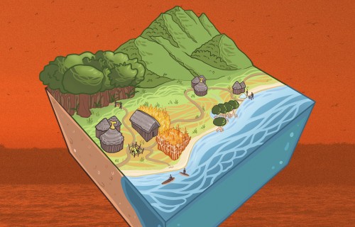
These maps dramatically illustrate how rising sea levels completely altered the shape of Panama’s coastline, creating islands and submerging large areas of land.
Since the last Ice Age, 12,000 years ago, we humans have enjoyed an unusually warm and stable geological period called the Holocene, and have made enormous agricultural and cultural advances as a result. But during the previous 2 million years, the world was much cooler and most of North America and Europe were locked under massive ice sheets up to several kilometers thick. Because so much of the world’s water was stored as ice, sea level was more than 100 meters lower than it is now, dramatically altering the shape of the land.
The ice sheets began to melt around 16,000 years ago, causing sea levels to shoot up as fast, and sometimes faster, than sea level rise humans are causing now by burning fossil fuels, until the climate stabilized around 8,000 years ago.

Panama coastline 26 thousand years before present. Sea level curve sourced from Miller et al. 2005.

Present day Panama coastline. Sea level curve sourced from Miller et al. 2005.
It was during this time of rapid sea level rise that humans arrived on the Isthmus of Panama. What was the landscape like when they came and how has it changed since? When were Panama’s islands cut off from the mainland? And when did modern marine ecosystems become established? With these questions in mind, Max Titcomb, an intern in Aaron O’Dea’s lab, modelled the impact of this great flood during the last 26,000 years, producing a suite of exquisite images and videos.
To produce the images, Max worked closely with STRI GIS expert Milton Solano and sought out non-proprietary bathymetric data from the United Kingdom’s Hydrographic Office (UKHO) and the Instituto Geográfico Nacional Tommy Guardia, in Panama, which he then digitized. Max notes that much information is still missing. “The models could be improved but these videos and maps provide a useful historical estimation of changes in Panama,” said Max “and the data are freely available on the STRI GIS portal and can be upgraded as new information becomes available”.
Max produced three models: One of the entire Isthmus and two focusing in on areas of special interest: the island archipelagos of Bocas del Toro (Caribbean) and Coiba (Pacific). The models show how the islands in both archipelagoes were connected to the mainland and the successive timing of their separations.

Coiba 26 thousand years before present. Sea level curve sourced from Miller et al. 2005.

Present day Coiba. Sea level curve sourced from Miller et al. 2005.
The models do not take sedimentation or tectonic uplift and subsidence into account which would change the shape of the shoreline.
“This is a project in progress,” O’Dea said. “Max did an amazing job producing these gorgeous maps. They will prove a useful guide for palaeontologists, archeologists and anyone interested in knowing what things were like in the recent past and how dramatically conditions have changed in a relatively short period of time.”
“We've been needing this for a while now!” said Ashley Sharpe, STRI archeologist not involved in the study, who welcomed the new models. “These maps will help us find evidence of the earliest archaeological sites on the Isthmus.”

Bocas Del Toro, Bay of Almirante 26 thousand years before present. Sea level curve sourced from Miller et al. 2005.

Present day Bocas Del Toro, Bay of Almirante. Sea level curve sourced from Miller et al. 2005.
“It was incredibly fun to work on this project,” Titcomb said. “Feel free to reach out to us if you have any questions or suggestions and please share with anyone who might benefit.”
All of the videos can been seen on https://storymaps.arcgis.com/stories/1d730fe1f6e443eab423a5aeea51dfb9 and the data is free to download for anyone to use.
Titcomb M. and O’Dea A. 2020. Post-glacial Sea Level rise on the Isthmus of Panama. DOI: https://doi.org/10.25573/data.11919276.
Share On
Related stories


PollenGeo. Unlocking the full potential of palynology (Public talk in Spanish)
Marine resource use has influenced human population on the Central American Isthmus for millennia
Human fishing reshaped Caribbean
reef food webs, 7000-year old
exposed fossilized reefs reveal
Archaeologists study the connections
between the deceased buried at
Cerro Juan Díaz, Panama
Rediscovering the Undiscovered: Revitalizing the Cerro Juan Diaz Archaeological Ceramic Collection (Presentation in Spanish)

How frogs’ superpowers may have led to life on land
New species of grapes are the oldest in the Western Hemisphere

New, giant horned dinosaur discovered in the ancient swamps of Montana, United States
An extinct mangrove forest discovered on Panama’s Barro Colorado Island
Wishing farewell to our friend, Dr. Richard Cooke
Extraordinary fossil find reveals details about the weight and diet of extinct saber-toothed marsupial