


How katydid songs expand
researchers’ knowledge of
tropical insects

Good
News!
Recovery of the
Juan Diaz mangroves
October 22, 2021
Over the last 50 years, since 1972, Panama has lost almost 50% of its mangroves primarily due to urban expansion and the conversion of mangroves into agricultural land.
The mangroves close to the township of Juan Diaz are one of many mangrove forests found along the shores of the Gulf of Panama from the province of Los Santos to the Darien.
Mangroves have the unique ability among plant species to tolerate the salt water of the oceans. The most common mangrove species in the Bay of Panama—including those in Juan Diaz—are Black mangrove (Avicennia germinans), Red mangrove (Rhizophora mangle), Tea mangrove (Pelliciera rhizophorae) and Mangle Salado (Avicennia bicolor). Each species has a unique combination of characteristics, including salt-, flooding-, sediment- and drought tolerance, water dispersal (hydrochory) and the ability to colonize new coastal areas where there are fresh, unstable fine sediments.
Aerial view of the Juan Diaz mangrove showing mangrove dieback. Credit: Steven Paton, STRI.
Mangroves are a vitally important ecosystem, not only to a wide range of plant and animal species that make their homes among, on top of and even under mangrove trees, but also to humans because of their importance in protecting coastlines from erosion and storm surges, as well as their role as nurseries for many commercially important marine species, such as shrimp and fish, that spend at least part of their lives among the roots of the mangroves.
Over the last 50 years, since 1972, Panama has lost almost 50% of its mangroves primarily due to urban expansion and the conversion of mangroves into agricultural land. Very recently, a new threat has made itself known—severe drought. During 2015-16, Panama experienced one of the most severe droughts in its history. Data from the Panama Canal Authority (ACP for its initials in Spanish) and the Smithsonian Tropical Research Institute (STRI for its initials in English) show that precipitation during this period was 26% below average. The drought was the result of one of the most severe El Niño events in modern history. At the same time, the first reports of a mysterious loss of leaves among the mangroves in front of Panama Viejo and Juan Diaz townships began to surface.
View from the base of the UTP Eddy Flux tower of the Juan Diaz mangrove showing mangrove dieback. The Eddy Flux tower measures net ecosystem CO2 exchange, evaporation, and energy flux between the atmosphere and a forest. Credit: Steven Paton, STRI.
The first reports of mangrove defoliation were made by the Patronato de Panamá Viejo and professors from the Universidad Tecnológica de Panamá (UTP) in late 2015. News of the phenomenon quickly spread to SENACYT, STRI, and to the Universidad de Panamá. Several meetings were held, and the result was a project funded by SENACYT to monitor the area called “Estudio y Monitoreo de los Manglares de la Bahía de Panamá.” Between 2016 and 2019, this project involved a unique consortium of national and international researchers who provided the first scientific information about one of the largest mangrove die-back events ever documented in Panama, and possibly in the entire region.
The project was tasked with answering three questions: how wide-spread was the die-back, how badly were the mangroves affected, and what caused the trees to die?
To answer the first question, Steven Paton, leader of STRI’s Physical Monitoring Program, and Luz Cruz of SENACYT, organized a series of aerial photographic flights. A total of four flights were carried out (one with the support of Panama’s Servicio Nacional Aeronaval, SENAN) between November of 2016 and April of 2018. During each flight, Paton took hundreds of georeferenced, high-resolution photos of the entire coastline between Panama City and La Palma in the Darien Province. A composite of several of these photos clearly shows how badly the Juan Diaz mangrove had been affected by late 2016.


The photos from these flights revealed several things. First, the most affected mangroves were those closest to Panama City, from the neighborhood of Costa del Este to approximately 10km west of the Tocumen airport; as well as a second, even larger zone next to the Rio Maestra in Darien Province. Initial estimates showed that in some zones, mortality rates were as high as 80%. Drone photos taken by Dr. Alexis Baules, professor at the UTP, provided additional confirmation of Paton’s observations.


To investigate how badly the mangroves had been affected and by what, researchers from Instituto de Investigaciones Científicas y Servicios de Alta Tecnología (INDICASAT-AIP), the UTP, UP, United Nations Development Program (UNDP), the TOTH Research Lab, and the Smithsonian, with invaluable support from SENACYT, Ciudad de Saber and CENAMEP-AIP, studied the mangroves close to the city, as well as the mangrove near the Rió Maestra during the 2 ½ years duration of the program. A final report was published and presented to Panama’s Ministerio del Ambiente in 2019. In that report, researchers concluded that, contrary to popular belief at the time, the mangroves had almost certainly not been killed by insects, nor was the die-off directly related to human impacts such as pollution and high sedimentation rates. Instead, researchers hypothesized that the prolonged, El Niño-driven drought had probably been the primary cause and that the majority of the dead trees belonged to a single species, Avicennia germinans, one of the fastest-growing, but also drought sensitive, mangrove species in the region.
Positive changes: Aerial roots of black mangrove (Avicennia germin) growing near the Juan Díaz water treatment plant. This type of mangrove is of great importance because in Panama they are often the first to colonize a mudflat. The roots are especially good at trapping suspended sediments in water, facilitating rapid soil accumulation and subsequent colonization by other mangrove species and animals. Credit: Steven Paton, STRI.
In 2020, a new mangrove project began with the goal of continuing the research into the specific causes of the mangrove die-back; particularly why so many trees of the same species died while others did not. This project is funded by the French bank PARIBAS and is part of a large, international research project known as Coastal and marine biodiversity resilience to extreme events in Central America and the Caribbean (CORESCAM) whose aim is to study how coastal ecosystems such as mangroves, coral reefs and sea grasses respond to major impacts such as hurricanes, droughts and floods. This new project, led by STRI’s Steven Paton and Omar López, UTP and STRI Research Associate, is focused on the mangroves of Juan Diaz. The project combines aerial photography and muddy, on-the-ground research. López and Paton are working on establishing a series of permanent monitoring plots in the Juan Diaz mangroves where they will investigate mangrove mortality rates, regeneration, as well as a wide range of variables that they hope will allow them to better understand what factors were most important in determining what survived the El Niño drought and what did not.
Mangroves are a vitally important ecosystem, not only to a wide range of plant and animal species that make their homes among, on top of and even under mangrove trees, but also to humans because of their importance in protecting coastlines from erosion and storm surges, as well as their role as nurseries for many commercially important marine species, such as shrimp and fish, that spend at least part of their lives among the roots of the mangroves. Steven Paton, STRI.
Recovery of the Juan Diaz mangrove near to the water treatment plant. Credit: Steven Paton, STRI.
In addition to their primary research agenda, López and Paton also hope to document the mangroves’ eventual recovery, which they are very happy to report has finally begun. For the first time since so many mangroves died in 2015/6, they can report that some areas that had been mostly filled with dead and rotting trees as recently as 2020, are now filled with thousands upon thousands of new seedlings and saplings. Some of the biggest saplings have grown over two meters in less than two years. A aerial photographic flight in March of this year financed by the University of McGill as part of a project called Panama Research and Integrated Sustainability Model (PRISM, https://prism.research.mcgill.ca/) and in collaboration with Centro Regional para el Hemisferio Occidental (CREHO), provided evidence that the recovery of the mangroves is not restricted only to the area of Juan Diaz. López and Paton are optimistic that, given the opportunity, the mangroves will be looking like new in only a few more years.
The recovery of the mangroves and the survival of many of the organisms that live in the mangrove mud is being threatened by the accumulation of solid wastes resulting from waste mismanagement. Credit: Steven Paton, STRI.
López and Paton are currently working hard to secure additional funding to monitor and document this once-in-a-lifetime event – the recovery of a mangrove after a massive dieback. This new research will be important, not only for understanding the current recovery of the Juan Diaz mangroves, but also for understanding future dieback and recoveries which may become more frequent in the future as a result of Climate Change.
Reference: https://prism.research.mcgill.ca/
Share On
Related stories

Remembering
Luis D’Croz
Q?Bus begins its
journey around
Panama
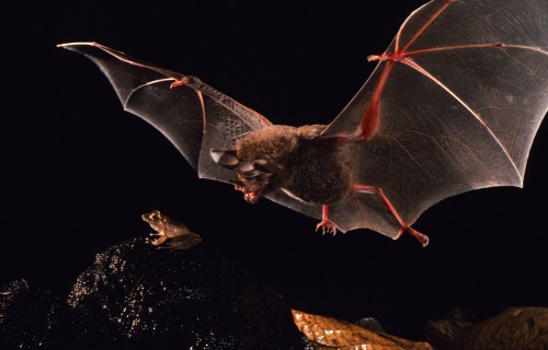
Palatable versus poisonous:
Eavesdropping bats must learn to
identify which prey is safe to eat
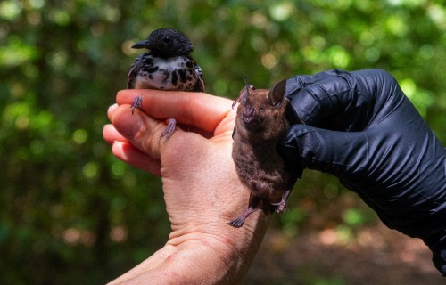
Birds by Day, Bats by Night:
Long-Term Census of Bats
and Birds in Panama
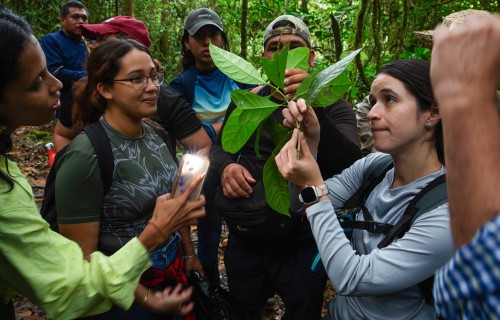
A course to learn about the
biodiversity of our forests
The first volumes of the BCI 100
celebration series are now
available online
Art and science converge in
Irene Kopelman’s latest work
The benefits of small-scale plantations for mammal species in mixed landscapes (Webinar in Spanish)
Wartime grant brings Ukrainian bat biologists to Panama

Between pasture and forest: the crusade to protect the jaguar in Panama